Hand County Emergency Management
SPECIAL SITUATION
December 22, 2022 Blizzard Event
Text to EM related to the blizzard and power outages.
The following is the text sent via email to AlertSense subscribers. If you got only a text and not an email, here is what we are doing and what we would like from those who do not have power.
December 22, 2022
The National Weather Service – Aberdeen issued a BLIZZARD WARNING for Hand and surrounding counties until Friday evening at 6 PM. A blizzard does not require new snow to fall, ground snow and winds can create a blizzard.
Travel throughout the county and region is currently “No Travel Advised” and it is likely that after sunset the travel advisories might change to show State and Federal Roadways as closed due to obstructions from drifting snow or stalled vehicles. County and township roadways have (historically) been worse than the SD-DOT maintained roadways.
At approximately 3:30 P.M. county emergency management was informed of power outages in Ree Heights (town). IThe power was restored at about 4:20 P.M.
In an effort to determine the number or and location of people without power, we are asking for you to message Hand County Emergency Management.
Here is the procedure:
Send a text to 605-299-2627. You may also email: [email protected]
This is a number which will forward your message to the Hand County Emergency Manager’s Email. Because of this, do not call, as this number is “text only”.
Provide your name, address and tell us how long your power has been off. Also tell us if you have provisions to shelter in place should the power remain out for a prolonged period of time, overnight for example.
We will compile a list / directory of those without power so we can converse with you directly. Texting requires less power and will allow you to conserve your battery power.
Thank you on behalf of the Emergency Management Team.
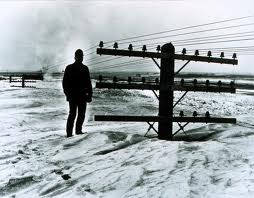
T his photograph from many decades ago represents the reality of living on the Northern Plains.
It doesn’t take long to turn an otherwise peaceful day into a disaster, whether the disaster is a natural event like a flash flood, hail
storm, ice storm or blizzard OR a man made event like a train derailment, overturned gas truck, explosion or criminal act of violence.
Emergency Management seeks to PREPARE responders through PLANNING so that an effective RESPONSE/RECOVERY can be made and MITIGATION plans can be drafted to minimize a re-occurrence in the future. Emergency Management (formerly called civil defense) seeks to help the public safety officials and members of the community to be prepared for just about anything. This is an ongoing project and requires a lot of work and especially team work to accomplish.
The contact and mailing information is as follows:
Hand County Emergency Management Arlen Gortmaker – Emergency Management Director 415 West 1st Avenue Suite 108 Miller, South Dakota 57362-1371 605-204-0267 (EM Office and Mobile) [email protected] State of South Dakota L.E.P.C. webpage: http://denr.sd.gov/des/gw/SARATitleIII/LEPC_Organization.aspx Hand County Storage Tanks Database – Click “Click Here to Search” and then enter the information that you are looking for. If you are looking for a specific property enter the address, and if you are unsure of the address you can search by just the City or County. Enter the information and then click “Execute Search”.If you have an abandoned storage tank you would like removed and possibly for free you can call the South Dakota Department of Environment and Natural Resource (DENR) at 605-773-3296 for more information.Hand County Spills Database – Open the County drop down menu and then choose “Hand”. Click the Submit button and it will open the spills for the county. Click on the ID No. for each spill and it will open the details of the spill.South Dakota Public Health Bulletin
2018 State and Local Agreement
The Emergency Management Performance Grant (EMPG) is a funding source provided by the United States Department of Homeland Security to states for the development and sustainment of emergency management programs. The state, in turn, makes a large portion of this funding available to county emergency management organizations through the State and Local Agreement(SLA).
Under the SLA, the county emergency management organization are required to achieve performance benchmarks in order to recieve federal funding. These benchmarks are reviewed annually by the state to coincide with state law and national priorities. Quarterly reports are submitted to the state by the county emergency manager documenting achieved benchmarks and eligible expenses and salaries for reimbursements up to 50%.
Here is the 2018 2018 SLA Workplan which details the benchmarks that need to be achieved and the 2018 SLA Administrative Manual document which identifies all coincide state law and national priorities that need to be followed.
Training Opportunities
Online Independent Study and NIMS training:
All first responders(EMS, Law Enforcement, Firefighters, ect.) and elected officials from both municipal and county level are required to take Incident Command Structure(ICS) 100, 200, and 700. The majority of ICS classes are found online for individuals to complete at their own pace. Before starting a class, first obtain a Student Identification(SID) number. Note: The SID number will be required before taking a final exam in each class. Once a class is completed the student will receive an email with a certificate. It is recommended to print or save the certificate for your records.
Click on the following link for a SID number: SID Number
Click on the following link for IS-100: Incident Command Structure-100
Click on the following link for IS-200: Incident Command Structure-200
Click on the following link for IS-700: National Incident Management System (NIMS)
Click on the following link for IS-800: National Response Framework (NRF)
Weather Information
SOUTH DAKOTA GRASSLAND FIRE MAP (NWS product) is found here: South Dakota Grassland Fire Map
SEVERE WEATHER OUTLOOK (Storm Prediction Center product) is found here: SPC Convective Outlook
Latest Watches, Warnings, & Advisories (NWS product) is found here: NWS Forecast Office Aberdeen,SD
Storm Spotting
Storm spotting is a essential and potentially life saving activity that the National Weather Service strongly supports. Because of this the NWS sponsors the SKYWARN Storm Spotter community which is made up of local volunteers found all across the United States. The community creates an interactive web that can help report severe weather phenomena to the nearest NWS office. For those that are presently storm spotters or are looking into becoming one having a Weather Field Guide on hand can greatly help yourself while out in the field. The guide will teach you spotter safety, basic thunderstorm structure, and helpful information to accurately spot funnel clouds and tornadoes from a safe distance. To be better prepared, it is highly recommended to read the guides once or twice before an actual severe outbreak occurs.
Advanced Spotters’ Field Guide
Weather Safety
Visit www.ready.gov for many emergency preparedness tips including preparedness for weather events.
2014 Winter Weather Preparedness Guide
Alert Text Messaging
Alert Sense publicalertsense.com
Pre-Disaster Mitigation (PDM)
In October of 2000, the Disaster Mitigation Act (DMA2K) was signed to amend the 1988 Robert T. Stafford Disaster Relief and Emergency Assistance Act. Section 322 of the Disaster Mitigation Act requires that local governments, as a condition of receiving federal disaster mitigation funds, have a pre-disaster mitigation (PDM) plan in place.
The purpose of this plan is to meet the hazard mitigation planning needs for Hand County and participating entities. Consistent with the Federal Emergency Management Agency’s guidelines, this plan will review all possible activities related to disasters to reach efficient solutions, link hazard management policies to specific activities, educate and facilitate communication with the public, build public and political support for mitigation activities, and develop implementation and planning requirements for future hazard mitigation projects.
The plan is renewed every five years. The process for renewal starts two years prior before the plan is officially adopted. The reason for this is to gather input from the public, business, and local governing bodies found in the county. All the potential hazards to the county, whether natural or man-made are also identified and addressed in the plan. The plan contains hazard mitigation projects that counter act the identified hazards to allow the governing bodies to apply for FEMA funds. The county has to adopt the PDM plan to be qualified to apply for these available federal funds.
Click the link to view the current adopted plan: Hand County PDM


